A major winter storm is headed for Maryland, bringing the possibility of heavy snow and icy conditions from Tuesday afternoon until Wednesday morning. This storm has prompted a Winter Storm Warning for most of the state, which means residents should prepare for challenging travel and hazardous conditions.
Timing & Impacts
The storm is expected to start affecting the area early in the afternoon on Tuesday. Snow will begin to fall in the southern parts of Maryland and gradually move north. Residents in the Baltimore-Washington region should be ready for snow to intensify by the evening, possibly accumulating up to 4 inches in some areas early on. By the time the storm wraps up late Tuesday night, some places may see more than 6 inches of snow, especially in southern Maryland.
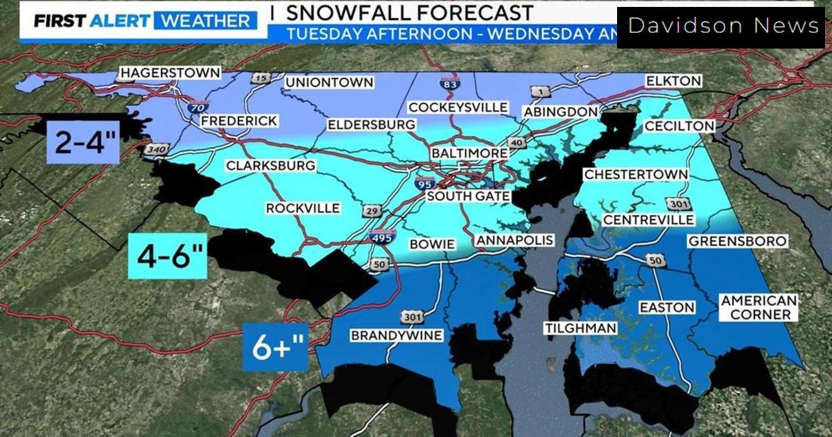
Potential Snow Accumulation
- Western Maryland and Pennsylvania border: 2 to 4 inches
- Southern Maryland: Expecting over 6 inches
- Other areas: Snowfall accumulation could vary greatly
This winter storm could produce snow accumulation rates of 1 to 2 inches per hour, resulting in rapidly changing conditions on the roads. Travel could become treacherous, especially as snow begins to cover roadways by Tuesday evening.
Wednesday’s Weather Outlook
As the storm continues into early Wednesday, temperatures should warm slightly, reaching the mid-30s, but this will not be enough to immediately improve road conditions. Another round of winter weather is also predicted, possibly bringing freezing rain and sleet on Wednesday evening into Thursday morning. Areas such as Carroll, Frederick, and Washington counties are likely to see the worst of these icy conditions.
What to Expect Post-Storm
After the storm, residents can look forward to a drier, milder Thursday with temperatures moving into the 40s. However, during the night, temperatures might drop back into the 20s and lower 30s. This fluctuation could lead to icy spots on untreated surfaces so drivers and walkers should exercise caution.
Weekend Weather Forecast
Looking ahead to the weekend, another weather system is approaching that might bring rain late Saturday into Sunday. Saturday’s highs are projected to hover near 40 degrees, while Sunday might see highs reach the mid-40s with the potential for rainfall tapering off later in the day. Residents should stay tuned for updates as conditions evolve.
Stay Informed and Prepared
As the winter storm approaches, it is crucial for everyone in affected areas to stay informed about the latest weather updates. Avoid travel if possible during the storm’s peak hours, and remember to check in with local authorities and weather services for persistent updates. Keeping a weather emergency kit is also wise, ensuring you have supplies in case of power outages or travel delays.
With this winter storm warning now in effect, Maryland residents are reminded to take appropriate precautions and stay safe during this potentially severe weather event.