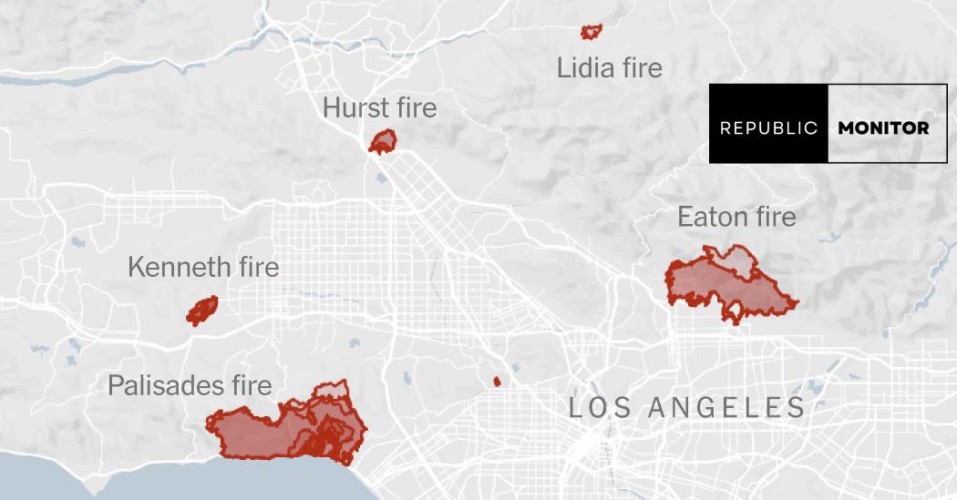
Recent wildfires in Los Angeles County have led to urgent evacuation warnings for thousands of residents, as raging flames fueled by fierce Santa Ana winds sweep through the area. The devastating Palisades and Eaton Fires have been particularly destructive, prompting officials to act swiftly in order to protect the safety of the community.
Maps: Tracking the Los Angeles Wildfires
As the fires spread rapidly across the hilly landscapes of Los Angeles, residents have turned to various resources to track the wildfires. Fire maps are now crucial in guiding evacuations, especially in densely populated areas where smoke and fire threaten homes and lives.
Extent of Recent Fires
Firefighters are working around the clock to contain the flames. The Palisades Fire, which started earlier this week, has already engulfed over 15,000 acres of land. Its intensity is alarming, with erratic winds pushing the flames into new territories, leading to a true race against time for firefighters and residents alike.
Evacuation Areas
Officials have mandated evacuations in multiple neighborhoods, prioritizing areas at the highest risk. Many families have had to leave their homes, often having just minutes to gather essentials. At least 30,000 people are currently under mandatory evacuation orders as the blazes continue to pose a significant risk.
The Human Impact of the Fires
With the fires come untold personal stories—families facing loss of homes, pets being rescued, and lives being altered indefinitely. Ten lives have already been lost in these wildfires, a tragedy that weighs heavily on the hearts of those living in affected communities. Local officials, such as Councilwoman Traci Park, have described this devastation as a “devastating loss” for Los Angeles. The community is rallying together, with many offering shelter and support to those in need.
Hazardous Air Quality and Safety Warnings
As the fires rage on, air quality has deteriorated significantly due to the massive amounts of smoke being released into the atmosphere. Residents are being advised to stay indoors to minimize health risks associated with the poor air quality. The county is working diligently to keep its citizens informed through alerts and safety warnings as the situation remains fluid.
Analysis of Satellite Imagery
| Feature | Description |
|---|---|
| Extent of Damage | Satellite images reveal extensive damage to both coastal areas and inland neighborhoods. Areas that once flourished are now unrecognizable, showcasing the ferocity of this year’s wildfire season. |
| Wind Gusts | Reports show wind gusts topping 90 mph over mountain peaks, contributing to the fast-moving nature of the fires and complicating containment efforts for firefighters. |
Investigations Underway
While containment efforts are ongoing, officials are also focused on understanding the causes of these fires. Cal Fire has launched investigations to determine what sparked the blazes amidst the dry conditions and low water supply, which adds a further challenge to firefighting efforts. The community continues to unite in hope and action, ready to support those affected during this critical time.
