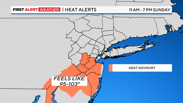
On Sunday, residents of Somerset, Middlesex, Monmouth, and Ocean Counties are under a Heat Advisory from 11 a.m. to 7 p.m. Temperatures are expected to soar, with heat indices reaching the upper 90s to low 100s due to high humidity. Concurrently, a high risk of rip currents is in effect at all south-facing beaches in New York throughout the weekend, posing significant dangers for beachgoers.
Saturday Night Storms
The forecast for Saturday night includes a Yellow Alert as a potent line of thunderstorms approaches the region. These storms, which have already prompted tornado warnings in Pennsylvania, are anticipated to reach the area with isolated severe conditions. The primary threats include heavy rain and gusty winds. After the initial storm line passes, a few more isolated storms may move through during the overnight hours, maintaining muggy conditions with lows remaining in the 70s.
Sunday Severe Storms
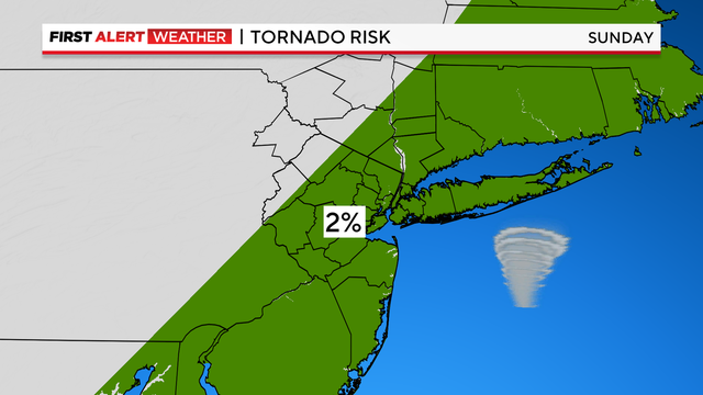
Sunday morning may see a few isolated storms before sunshine breaks out, causing temperatures to rise rapidly into the upper 80s and low 90s. With high humidity, the heat index will range from the upper 90s to the low 100s, particularly in central and southern New Jersey. This combination of heat and humidity will create a volatile atmosphere, priming it for strong to severe thunderstorms in the afternoon and evening.
These storms are expected to bring damaging winds, hail, torrential downpours, and possibly even isolated tornadoes. Given the tropical airmass in place, storms could produce substantial rainfall, potentially totaling between 2-3 inches in some areas. This heavy rainfall increases the risk of flash flooding, especially in low-lying regions and urban areas with poor drainage.
Post-Storm Conditions
As the storms move out, clearing skies and decreasing humidity levels are expected later Sunday night, bringing some relief from the oppressive weather. The transition will mark the end of the severe weather threat, providing a much-needed respite for residents.
Preparedness and Safety Measures
Given the severe weather forecast, residents are urged to take necessary precautions. The National Weather Service recommends staying hydrated and avoiding strenuous outdoor activities during the peak heat hours. Beachgoers should heed rip current warnings and avoid swimming in hazardous conditions.
For those in the path of the storms, it is essential to stay informed through weather updates and have an emergency plan in place. Secure outdoor objects that could become projectiles in high winds, and ensure that flashlights, batteries, and other emergency supplies are readily available. In the event of flash flooding, avoid driving through flooded areas and seek higher ground if necessary. Remember that it only takes a few inches of moving water to knock down a person or sweep a vehicle away.