The first tropical storm warning of this year’s hurricane season was issued early Tuesday, prompting coastal communities in southern Texas to brace for heavy rain, flooding, and potential tornadoes. The National Hurricane Center (NHC) reported that the storm, developing over the southern Gulf of Mexico, was expected to reach land as a potential tropical cyclone.

Formation and Path of the Storm
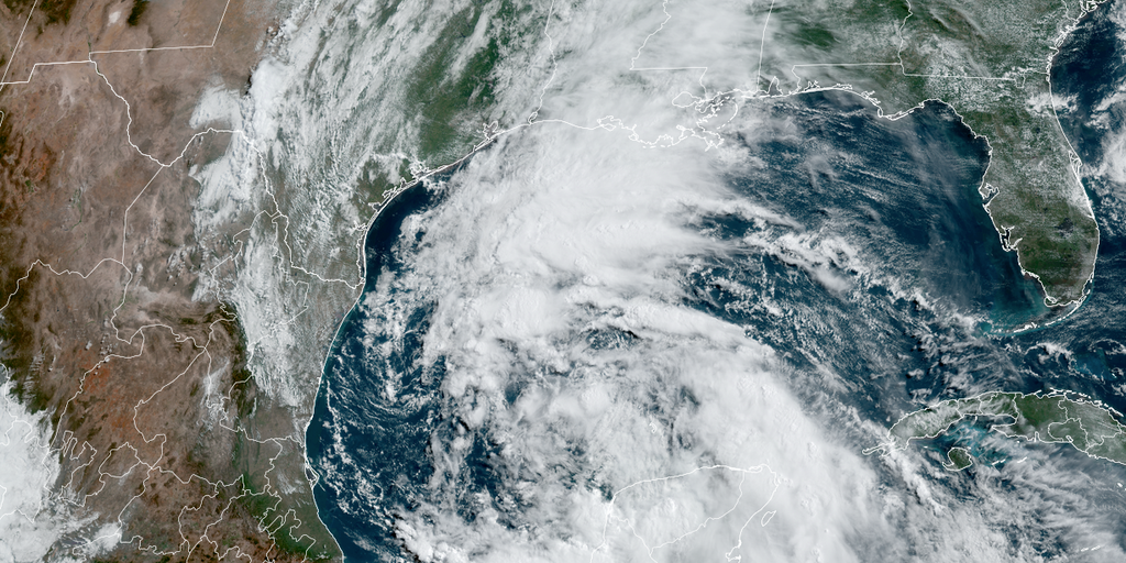
If the storm strengthens, it will become the season’s first named storm: Tropical Storm Alberto. As of Tuesday night, the system was centered approximately 365 miles southeast of Brownsville, Texas, and was predicted to become a tropical storm by Wednesday. It was forecasted to make landfall on Mexico’s Gulf Coast by Wednesday night. The NHC estimated an 80% chance of the system becoming a tropical storm within the next two days.
The tropical storm warning covers coastal Texas from San Luis Pass to the mouth of the Rio Grande and extends along the Gulf Coast of Mexico. The storm is expected to affect large parts of Central America with rainfall. Forecasts on Tuesday night indicated maximum sustained winds near 40 miles per hour, expected to increase over the next 36 hours. Downpours and coastal flooding were predicted over the coming days.
Impacts and Precautions for Coastal Communities
In Texas, moderate coastal flooding was anticipated to begin along the coast as early as Tuesday, worsening through midweek. The situation was expected to escalate on Wednesday in the tropical storm warning area, potentially causing flash flooding and urban flooding as rivers overflow. Northeastern Mexico could experience mudslides.
At 4 a.m. CT on Tuesday, the NHC upgraded the season’s first tropical storm watch to a tropical storm warning. By 7 a.m., Mexico’s government issued a tropical storm warning for the northeastern coast, south of the mouth of the Rio Grande to Puerto de Altamira, replacing the earlier watch.
The storm was moving northwest at 7 mph over the Gulf on Tuesday evening, with a projected westward turn overnight into Wednesday, before reaching northeastern Mexico by Wednesday night. Forecasts indicated that regions in northeastern Mexico and southern Texas could receive 5 to 10 inches of rainfall, with the possibility of more severe inundation in certain areas. Peak storm surge occurring in tandem with high tide could lead to flooding up to 4 feet above ground along the Gulf Coast in Texas and Mexico. The deepest water was predicted near the storm’s landfall location and to its north, with storm surge likely accompanied by large, dangerous waves. These conditions are expected to create life-threatening surf and rip currents.
Understanding Tropical Cyclones and Hurricane Season
The Atlantic hurricane season officially began on June 1 and will run through the end of November. Most storm activity typically occurs from mid-August to mid-October. The terms “hurricane” and “tropical cyclone” refer to the same type of storm, with “tropical cyclone” serving as a broad classification for rotating, low-level cloud systems and thunderstorms over tropical or subtropical waters, according to the National Oceanic and Atmospheric Administration (NOAA).
A tropical cyclone becomes a tropical storm once its maximum wind speeds exceed 39 mph. When sustained winds reach 74 mph or higher, it is classified as a hurricane. As communities along the Gulf Coast prepare for the potential impacts of Tropical Storm Alberto, the importance of understanding and respecting these powerful natural phenomena cannot be overstated.